From the NHC:

Our guess was that it would be the very warm water off northern Georgia that turbocharged the storm but now the NHC has that occurring further south, just west of the Bahamas.
And possibly stronger than Cat. 1:
A central pressure as low as the 960's gets you to a high cat 2 or low cat 3 although nowhere near the record holders.Here's the version with the full-tracks and minimum MSLP.
Note, there are some intense (960s central
pressure) scenarios on the board. pic.twitter.com/N92GE4IRN4
— Ryan Maue (@RyanMaue) July 30, 2020
2015's Hurricane Patricia made landfall on the west coast of Mexico with central pressure having been measured at 880 mb and winds at 200 mph.
As noted in the outro from last month's "Could a hurricane lash Los Angeles? 80 years ago, this deadly storm came close":
....In late October 2015 one of the most amazing storms in recent history occurred:
"Stunning, historic, mind-blogging, and catastrophic: Hurricane Patrica Hits 200 mph"
National Hurricane Center: "...POTENTIALLY CATASTROPHIC HURRICANE PATRICIA MOVING NORTHWARD TOWARD LANDFALL IN SOUTHWESTERN MEXICO..."
The National Hurricane Center Calls Patricia "THE STRONGEST EASTERN NORTH PACIFIC HURRICANE ON RECORD."
Which were followed by:
The Astonishingly Light Damage Caused By Hurricane Patricia
Still, you have to respect those Pacific storms. Depending on where they form they can be not just powerful but huge:
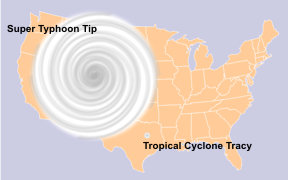

That's 1979's super-typhoon Tip, a bit less than half the size of the contiguous United States.
Secondly they can develop very high wind speeds. In 1996 Severe Tropical Cyclone Olivia had a wind gust measured at 253mph, the world record non-tornadic wind speed.