September 1939 was a stormy month on the world stage. On Sept. 1, Hitler invaded Poland. On Sept.3, Britain, France, Australia and New Zealand responded by declaring war on Germany. In Los Angeles that month, as residents sweated through an unusual heat wave and nervously watched the storm clouds of World War II gathering overseas, four tropical cyclones that would affect Southern California were born in the eastern North Pacific.
No tropical cyclones had made it north of 25 degrees latitude in the northeastern Pacific basin during all of 1937 and 1938. Then in 1939 there were four such storms in the space of a month, including an unnamed tropical storm that came ashore in San Pedro, dropping torrential rain totaling 5.62 inches on Los Angeles from Sept. 24-26.
It battered Southern California with wind gusts to 65 mph, according to the Los Angeles Times, damaging boats, structures, utility lines and crops. Forty-five people were killed by flooding throughout Southern California, and an additional 48 died at sea. It’s the only tropical storm to make landfall in California during the 20th century.
That was 80 years ago next month, during the El Niño of 1939-40.
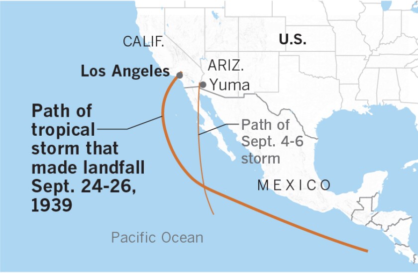
Paths of the first and fourth in a series of September 1939 storms that affected Southern California, with the fourth one making landfall as a tropical storm. Two others dissipated before reaching the Southland, but influenced the area.
Storms such as this have been given the name el Cordonazo de San Francisco by fishermen in the villages along the Pacific Coast of Mexico. The name means “the Lash of St. Francis,” because they occur in the fall, close to the Oct. 4 feast of St. Francis of Assisi.
As Bill Patzert, retired NASA Jet Propulsion Laboratory climatologist, points out, the eastern side of these Cordonazo storms would severely lash the communities on the Pacific Coast of Central America from southern Mexico to Baja. For centuries, the damage was brutal. The Cordonazo lash isn’t felt so harshly or frequently in Southern California.
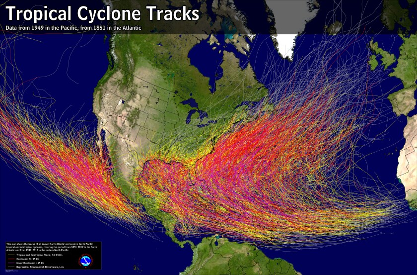
Tropical cyclones that form in the eastern North Pacific near the west coast of Mexico track to the northwest toward Hawaii, for the most part. This stretch of the ocean has few islands and the shipping lanes aren’t frequently traveled. Until the 1960s when it became possible to detect storms with regular satellite coverage, the fecundity of this region in terms of cyclone production wasn’t appreciated.....MUCH MORE
Various popular explanations suggested that St. Francis used his belt or cord to hit the clouds and make them dump their heavy rain, producing lightning and thunder. The Cordonazo season marks the beginning of the end of the rainy season in Central America. Some stories have St. Francis driving out the devil with his cord, resulting in big storms, thunder and lightning flashes as the devil was chased back into hell.
When people think of hurricanes, many think of the Gulf of Mexico, the Caribbean Sea and the U.S. Eastern Seaboard — in fact, the name comes from “Hurican,” the Carib Indian name for the god of evil — but the most active hurricane region in the world is the western North Pacific, an area responsible for one-third of the planet’s annual average of 79 tropical cyclones.
The second-most prolific hurricane-producing area is the eastern North Pacific, averaging 13 storms per year. It is in this part of the world that L.A.’s September 1939 storm was born.....
In late October 2015 one of the most amazing storms in recent history occurred:
"Stunning, historic, mind-blogging, and catastrophic: Hurricane Patrica Hits 200 mph"
National Hurricane Center: "...POTENTIALLY CATASTROPHIC HURRICANE PATRICIA MOVING NORTHWARD TOWARD LANDFALL IN SOUTHWESTERN MEXICO..."
The National Hurricane Center Calls Patricia "THE STRONGEST EASTERN NORTH PACIFIC HURRICANE ON RECORD."
Which were followed by:
The Astonishingly Light Damage Caused By Hurricane Patricia
Still, you have to respect these Pacific storms. Depending on where they form they can be not just powerful but huge:
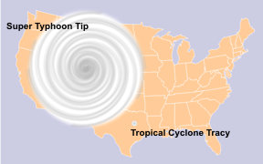

That's 1979's super-typhoon Tip, a bit less than half the size of the contiguous United States.
Secondly they can develop very high wind speeds. In 1996 Severe Tropical Cyclone Olivia had a wind gust measured at 253mph, the world record non-tornadic wind speed.