Hurricane landfall risks less elevated than activity in 2020: Twelve Capital
During the 2020 Atlantic tropical storm and hurricane season two regions to watch for above average levels of storm activity are the tropical Atlantic’s main development region (MDR) and the Gulf region, according to ILS investment manager Twelve Capital.[Climateer here, that comment is almost a tautology as far as insured risks go]
But while these two regions are the ones expected to see activity levels the furthest above averages, the insurance-linked securities (ILS), catastrophe bond and reinsurance focused investment manager’s analysis suggests that while forecasts point to above average storm and hurricane activity, landfall risk is seen to be rising more slowly.
Twelve Capital works with machine learning focused climate technology company reask on hurricane risks and the pair have developed a proprietary North Atlantic hurricane seasonal forecast methodology.
With this modelling work, Twelve Capital aims to benefit from a more complete insurance risk assessment framework, when it comes to hurricane risk, incorporating a measure of regional hurricane landfall risk.
Forecasts for the 2020 Atlantic hurricane season largely suggest a well-above average level of activity, in terms of tropical storms, hurricanes and major hurricanes as well.
But the analysis undertaken by Twelve Capital and reask shows that this doesn’t always mean a corresponding increase in landfalls and as a result doesn’t have to mean insurance and reinsurance market losses will be significantly above average as well.
It’s important to note, of course, that it does only take one hurricane to make landfall in a region such as Florida for losses to balloon and the analysis is an indicative and machine learning driven look at climatology related factors and how they could influence the hurricane season.
Twelve Capital and reask’s analysis highlights which areas look destined for the most activity, picking out the Atlantic’s main development region (MDR) and the Gulf region as the two which are forecast to see the highest activity levels.....MUCH MORE
While there is a higher probability that more storms form in the 2020 tropical storm season, the analysis highlights the MDR in particular, as Twelve Capital says, “MDR activity is a key area of focus for potential insurance risk.”....
One of the reasons that conditions were considered more favorable for storms to form is the forecast for the El Niño/Southern Oscillation, which for most of this year looked as if it would get to full-blown La Niña* (leading to less wind shear in the Atlantic) but that may not happen.
From the ENSO blog at climate.gov (Michelle L’Heureux, Proprietor):
June 2020 ENSO update: pet projects
After several months of hovering above average, sea surface temperatures in the tropical Pacific have dropped rapidly in recent weeks. The current CPC/IRI ENSO forecast estimates about a 60% chance that ENSO-neutral conditions will remain through the summer. Chances for the fall and winter are about equally split between neutral continuing and La Niña developing, at around 45% each. El Niño isn’t completely ruled out, but it is less likely, with a chance of about 10%.
June finds us starting to emerge from the spring predictability barrier, when computer models are less successful at predicting how ENSO will behave. However, the models and nature aren’t showing strong signs, which is reflected in the approximately even odds between neutral and La Niña.
Puppies and kittens
Before I get into the forecast, let’s take a look at how conditions have evolved in the tropical Pacific over the past few months.
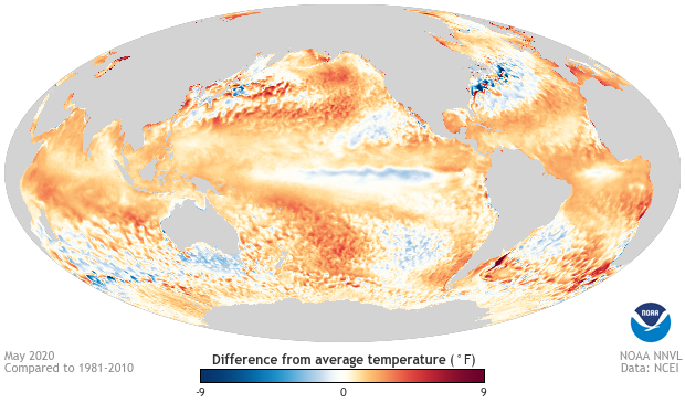
May 2020 sea surface temperature departure from the 1981-2010 average. Image from Data Snapshots on Climate.gov.
The weekly Niño3.4 index, which measures the sea surface temperature departure from the long-term average in the east-central equatorial Pacific, cooled by a full degree Celsius (1.8°F) since mid-April. Over one week in May, the Niño3.4 index dropped by half a degree Celsius. Water has a high heat capacity, meaning it takes a lot of heat to change the temperature, so rapid changes are uncommon. According to this post by Michelle, a half-degree week-to-week change is quite rare, happening about 1% of the time........MUCH MORE
* El Niño "conditions" begin at a half-degree above the zero line while a full blown El Niño is declared after three rolling three month periods (five consecutive months) above +0.5°C.
IRI/Columbia have not yet released their plume of the model runs for June so here is the May 19th version, still showing a La Niña right at the peak of the hurricane season, September/October/November:
