The U.S. National Oceanic and Atmospheric Administration’s Climate Prediction Center says there is a 30% chance that the 2019 Atlantic hurricane season sees above normal levels of activity and warns of factors including El Nino and a warmer than normal Atlantic that can affect intensity of the season.
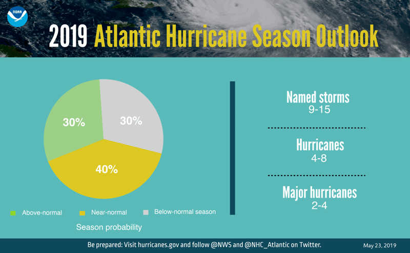
Overall, a near-normal Atlantic hurricane season is forecast, with a 40% chance of being near-normal season, a 30% chance it is above-normal season and a 30% chance of a below-normal season.
This leads NOAA to forecast that between 9 to 15 named storms (winds of 39 mph or higher) will form during the 2019 hurricane season, 4 to 8 of which may become hurricanes (winds of 74 mph or higher), with from 2 to 4 forecast to become major hurricanes (category 3, 4 or 5; with winds of 111 mph or higher).
NOAA gives a 70% range of confidence for this forecast, which predicts slightly more hurricanes and major hurricanes than others of the main forecasters that we track here.That El Niño forecast is directly at odds with Australia's BoM.
The ongoing El Nino conditions are expected to persist and suppress the intensity of the hurricane season, NOAA explains.
But, countering this, the administration also notes that an expected combination of warmer-than-average sea-surface temperatures in the tropical Atlantic Ocean and Caribbean Sea, as well as an enhanced west African monsoon, will both favor increased hurricane activity....MORE
As noted a couple weeks ago in "Hurricane Watch: Australia's Bureau of Meteorology Lowers Odds of Full-Blown El Niño":
Long time readers know the El Niño/Southern Oscillation, through a couple teleconnections influences the North Atlantic hurricane season. Stronger/longer El Niño tends to correlate with fewer hurricanes, La Niña tends toward more 'canes....And it's not just a less powerful El Niño that raises the chances for a more active hurricane season.
***...Look for later hurricane season forecasts to add one or two more hurricnes than the earlier guesses.
The BOM is one of our big three public sources on ENSO conditions, along with Columbia Uni/IRI and the US. NOAA.
For El Niño Modoki situations Japan's Japan Agency for Marine-Earth Science and Technology (JAMSTEC) is the go-to.
Finally, the comment thread on this NOAA page seems to be leaning toward a Modoki:...
Should the above mentioned Modoki variation be the summer-of-2019 story we hark back to this 2009 post:
New Type Of El Nino Could Mean More Hurricanes Make Landfall
... "Normally, El Niño results in diminished hurricanes in the Atlantic, but this new type is resulting in a greater number of hurricanes with greater frequency and more potential to make landfall," said Peter Webster, professor at Georgia Tech's School of Earth and Atmospheric Sciences.The official start to hurricane season is Saturday, June 1.
That's because this new type of El Niño, known as El Niño Modoki (from the Japanese meaning "similar, but different"), forms in the Central Pacific, rather than the Eastern Pacific as the typical El Niño event does. Warming in the Central Pacific is associated with a higher storm frequency and a greater potential for making landfall along the Gulf coast and the coast of Central America....
Stay tuned.