The fact of the vortex forming is less important than what the jet stream does. From a December 2019 post:
So You Want to Be a Natural Gas Trader?
...As we've been saying for a couple months, Jet Stream!
"The market is trading off the cold snap and the cold snap is not going to last" because we are currently experiencing a meridional (north - south) jet stream that progresses in stately fashion from California to New York, alternating cold and warm:
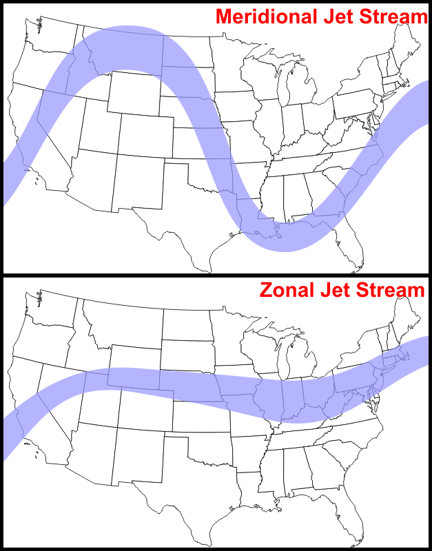
The meridional pattern can set up a nice long-then-short-then long sequence in natural gas futures trading.
Except when it dips too far and you have Texas guzzling gas like Minnesota. Or if the pattern stalls and the warmth is delayed.
Or if it changes to a zonal pattern.
The zonal jet stream pattern keeps the cold air on the north side of the big wind (British Airways 747 Reached Speeds of 825 mph Riding Jet Stream New York to London) allowing the cold to intensify whereas the meridional pattern allows the cold air to slide down to more populated areas of North America and Europe which gives rise to the misuse of the term polar vortex and makes natural gas traders (if they are nimble) some money.
The thing to be aware of with the meridional flow is the whole pattern moves west to east, meaning the places that get the frigid blast then feel the warm air that follows the cold dips.
From The Watchers, September 11:
As the winter season of 2023/2024 approaches, a newly forming Polar Vortex is drawing attention in the Stratosphere over the North Pole. Its rapid intensification could lead to significant weather impacts for parts of North America and Europe.
- With the current atmospheric dynamics, including the east phase of the Quasi-Biennial Oscillation (QBO) and the El Niño phase, there’s an increased likelihood of colder winters in the US, Canada, and Europe. Additionally, there’s an anticipated above-average snowfall across the eastern US and Europe.
The term “Polar Vortex” has varying definitions. However, in the context of our winter weather, its importance lies in its strength, as it determines the weather conditions we experience at the surface.
Come autumn, the polar regions start to cool down due to the diminishing angle of the sun, receiving minimal solar energy. In contrast, regions further south continue to receive ample sunlight. This stark temperature difference between the poles and subtropical areas results in the formation of a low-pressure circulation known as the Polar Vortex. This circulation spans from the earth’s surface to the upper reaches of the atmosphere.
A strong Polar Vortex implies a robust polar circulation, which typically contains the colder air in the polar regions, resulting in milder conditions across places like the US and Europe. Conversely, a weak Polar Vortex means the colder arctic air is not confined and can flow into regions like the US and Europe, leading to cooler conditions.
Current developments in the stratosphere
The North Pole has already begun its cooling process, traditionally initiating in August and intensifying in the ensuing months. The Polar Vortex is expected to be at its peak strength during November and December. Current forecasts for September highlight a rapidly developing and expanding Polar Vortex, which, with increasing strength, will have a more pronounced influence on our surface weather.Analysis from the ECMWF seasonal forecast reveals the Quasi-Biennial Oscillation (QBO) is currently in its east (negative) phase. This indicates the potential for a weaker jet stream, sudden stratospheric warming events, and colder winters across the US, Canada, and Europe.
Potential effects and implications
During an easterly QBO, the Polar Vortex and stratospheric winter circulation tend to be weaker, leading to an increased likelihood of Sudden Stratospheric Warming (SSW) events. Such events can disrupt the Polar Vortex, resulting in weather impacts across the Northern Hemisphere. These include disruptions in the jet stream and a release of colder Arctic air into Europe and the US....
....MUCH MORE
The QBO is just one of the factors that influence the jet stream pattern and because we are dealing with a complex chaotic system, long range jet stream forecasts can be tricky.
Things get really tricky when you superimpose another complex-chaotic system, markets—with their Keynesian beauty contests and Brownian-type movement-morphing into murmuration-like crowd behavior—on top of the weather/climate stuff:
We will update as we get deeper into the Northern Hemisphere winter.