Now it's a Cat 4.
From the Washington Post:
Monster super typhoon Sanba aims at Okinawa and South Korea

Satellite image of super typhoon Sanba in the western Pacific, south of South Korea and Japan (NOAA) A large, dangerous typhoon has rapidly gained strength in the western Pacific. Super typhoon Sanba, positioned 690 miles south of Kadena Air Force base, Japan, has peak winds of 155 mph, the equivalent of strong category 4 hurricane, on the cusp of category 5.
The storm is headed due north, on a path to pass very near the island of Okinawa, Japan late Saturday or early Sunday local time. After that, the storm is forecast to continue due north towards the southern tip of South Korea Monday, although southern mainland Japan is within the range of possible tracks....MORE
...In the longer-range, the storm may have implications for the weather in the eastern United States, perhaps playing a role in the cool pattern forecast to develop writes Grand Rapids meteorologist Bill Steffen:
Typhoons that move north and then northeast in the Western Pacific can change the upper level wind pattern…creating a trough south of Alaska, a ridge over the Western U.S. (where it gets quite warm) and then a trough over the Great Lakes/Northeast. I think Sanba will do that...Also at the WaPo:
Cool snap coming into central and eastern U.S. next week?
It's probaly a good idea to keep an eye on anything called "Monster Super Typhoon".
GFS forecast temperatures compared to 1981-2010 average next week ( WeatherBellModels.com )...MORE
Those Pacific Ocean storms can get pretty big-
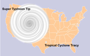
Here's 1979's Super Typhoon Tip:
The relative sizes of the United States, Typhoon Tip and Cyclone Tracy (the largest and smallest Pacific tropical cyclones recorded, respectively)

