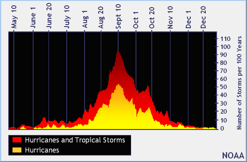
Keeping in mind that September 10 is the statistical high point of the season:

The official hurricane season for the Atlantic Basin (the Atlantic Ocean, the Caribbean Sea, and the Gulf of Mexico) is from 1 June to 30 November. As seen in the graph above, the peak of the season is from mid-August to late October. However, deadly hurricanes can occur anytime in the hurricane season.
And although the Gulf of Mexico-bred storms can pop up at any time, August is when we have to start thinking about the Cape Verde storms that make that long run from the Main Development Zone.
As NASA says:
....The average Atlantic Hurricane season brings with it approximately two Cape Verde hurricanes. These hurricanes are usually the most intense and the biggest storms of the season because they develop so far to the east and can travel over a large area of warm, open ocean waters that help power them. There are also no land forms in the way to slow tropical cyclones if they form near the Cape Verde Islands....
And from PhD hurricane geek Ryan Maue:
A look at Atlantic as modeled / potential systems come off the coast of Africa during the next 6-weeks.
— Ryan Maue (@RyanMaue) August 3, 2021
Each simulation (ensemble) is worth 2% of the total, so if you can count at least 100 tropicals, then that's going to yield on average 2 actual named storms.@weathermodels_ pic.twitter.com/jHk5pq46aS
Although worldwide cyclones are running almost exactly average:
2021 Accumulated Cyclone Energy
That's a June 8 post but it updates daily.