From Wunderblog:
Today's guest blog post is by Dr. Michael Ventrice, an operational scientist for the Energy team at Weather Services International (WSI) - Jeff Masters
We are seeing increasing evidence of an upcoming change in the Pacific Ocean base state that favors the development of a moderate-to-strong El Niño event this Spring/Summer. To begin, here is a snap shot of global sea-surface temperature (SST) anomalies (the departure of temperature from average) 30 days ago:
Note the relatively weak look to the SST anomaly pattern in the equatorial Pacific, with warm anomalies in the western half of the basin and mixed warm and cold anomalies in the eastern half of the basin. The mixed warm/cold signals in the equatorial eastern Pacific are the result of instability “easterly” waves in the ocean, which are associated with short distances between “warm” and “cold” phases. Now let’s compare to what the SST anomaly map looks this week:
We’ve observed strong cooling in the eastern half of the Pacific Basin, giving a spatial map that strongly resembles “La Niña”--the opposite of El Niño. So why I am pushing the idea that El Niño might be right around the corner if the map looks like La Niña!?
It comes down to ocean dynamics. There are other types of waves that are deep in the Pacific Ocean. One such wave is called an “Oceanic Kelvin Wave”. Oceanic Kelvin waves travel only from West to East at extremely slow speeds (2-3 m/s). These waves have been alluded to as the facilitators of El Niño. There two phases of an Oceanic Kelvin wave, the “Upwelling” phase and the “Downwelling” phase. The Upwelling phase of an Oceanic Kelvin wave pushes colder water from the sub-surface towards the surface, resulting in cooling at the surface. The Downwelling phase of an Oceanic Kelvin wave is the opposite, where warmer waters at the surface of the West Pacific warm pool are forced to sink, resulting a deepening of the thermocline and net warming in the sub-surface. To try to illustrate this, imagine someone holding a blanket. They rapidly lift the blanket up (Step 2) and then push it back down (Step 3).
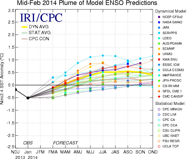
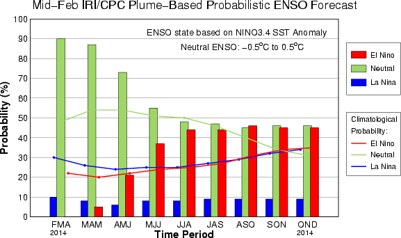
You will get a wave in the blanket, where it travels from the source region (you) towards the opposite direction. This same exact thing happens during Oceanic Kelvin wave events, where the general wave pattern will propagate from west to east. Since Oceanic Kelvin waves travel only from west to the east, you can expect when one phase is located over a region (i.e., today an “Upwelling” phase is in the East Pacific), the opposite phase will soon to follow (i.e., the “Downwelling” phase will be in the East Pacific in 1-2 months). It may be appropriate to illustrate the evolution of the 1997 Super El Niño event to shed some more light on the similarities of the pattern then when compared to now....MOREHere are the current (as of Mid Feb.) projections from IRI and Columbia's Earth Institute:

