If the forecasted early breakdown of the polar vortex comes to pass, allowing Polar air to head south, the recent riots will be fondly looked back upon as 'the quiet time.'
From OilPrice, October 26:
Europe’s benchmark natural gas price jumped by 2% at opening in Amsterdam on Monday, extending the 7% weekly gain from last week, as concerns mount that the gas withdrawal season has started amid no signs that Qatar’s LNG flows would return anytime soon.
The front-month price at the Dutch Title Transfer Facility (TTF), the benchmark for Europe’s gas trading, rose by 2.1% to as much as $107.40 (95.73 euros) per megawatt-hour (MWh) early on Monday, reaching its highest level since 2022.
The European natural gas price is now at its highest levels since the autumn of 2022, when Europe faced the first winter without most of the Russian pipeline gas supply. The current price is also equivalent to more than $30 per million British thermal units (MMBtu).
The TTF price rallied by 7% last week as several EU countries began withdrawing gas from storage amid lower temperatures....
....MUCH MORE
From Severe Weather Europe, October 28:
Polar Vortex Split Forecast: The Earliest Stratospheric Warming on Record Is Coming
The Polar Vortex is heading toward a record early disruption. The latest forecasts show stratospheric winds collapsing toward a full reversal in early November, splitting the Polar Vortex into two separate cores. If the reversal happens, it will be the earliest Sudden Stratospheric Warming on record, by at least three weeks.
An event this early is uncharted territory. With a Super El Niño already shaping the weather pattern, the impacts are harder to track than in mid-winter. But forecasts already show the first indirect links to the split cores, with cooler trends developing over parts of Europe and the eastern United States in coming weeks.
In this article, I look at the developing Polar Vortex split and the Stratospheric Warming, how deep it reaches through the atmosphere, and what it could mean for the weather in the mid-range. I also look at why the long-range data points to an even stronger disruption in mid-winter 2026/2027.
The Polar Vortex is a broad winter circulation over the northern (and southern) hemispheres. You can imagine the Polar Vortex as a spinning wall over the polar regions, rising from the surface into the stratosphere (over 50 km/31 miles high), trapping the cold polar air inside.
The Polar Vortex is divided into two layers: the stratosphere (at higher altitudes) and the troposphere (at lower altitudes). These two layers are connected but can often behave differently. A strong, stable Polar Vortex acts like a barrier, locking the coldest air into the North Pole, creating milder conditions for the United States and Europe. Image: NOAA
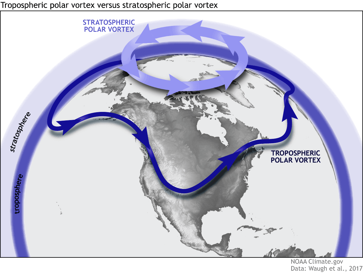
When the Polar Vortex is disrupted or “collapses,” this polar barrier breaks, allowing cold Arctic air to spill southward into the mid-latitudes. But this early in the season, the Polar Vortex is still building up for winter, so a disruption now behaves differently than in mid-winter.
Below is an example from NOAA of how a disrupted Polar Vortex releases cold polar air into the United States or Europe in winter.....
....MUCH MORE

