The most amazing of the super-windy storms was Hurricane Patricia in October 2015. At the time we posted "The National Hurricane Center Calls Patricia 'THE STRONGEST EASTERN NORTH PACIFIC HURRICANE ON RECORD.'" on the 23rd the sustained winds were 200mph. They eventually got to 215mph just before landfall.
And then nothing.*
From Popular Science, February 8:
Our go-to five-category scale may no longer be enough.
As ocean temperatures skyrocket to new records, hurricanes are getting stronger and more destructive. According to new research, the five-category Saffir-Simpson Windscale may need to add a Category 6 with a minimum wind threshold of 192 miles per hour and, potentially, even a Category 7.
According to a peer-reviewed research article published February 5 in the journal Proceedings of the National Academy of Sciences (PNAS), five storms within the past decade have had wind speeds so strong that they could be classified as a hypothetical Category 6 tropical storm. The Saffir-Simpson Windscale currently lists Category 1 storms as those with wind speeds between 74 and 95 mph. Category 5 storms as those with wind speeds 158 mph. Some of the five storms in recent years that could fit a hypothetical Category 6 had winds over 200 mph.
“Our motivation is to reconsider how the open-endedness of the Saffir-Simpson Scale can lead to underestimation of risk, and, in particular, how this underestimation becomes increasingly problematic in a warming world,” study co-author and climate scientist Michael Wehner of Lawrence Berkeley National Laboratory said in a statement.
Human-caused global warming has significantly increased both surface ocean and tropospheric air temperatures in the regions where tropical cyclones, typhoons, and hurricanes form. The warm temperatures provide extra energy for the storms with which to intensify. In August 2023, Hurricane Idhalia rapidly intensified from a Category 2 storm to a Category 4 storm, but eventually hit the Big Bend region of Florida as a Category 3 with sustained winds of 125 miles per hour. Tropical storms typically lose some steam as they hit land and are no longer over the warm water that they use for fuel. However, some storms like 2017’s Hurricane Harvey can produce so much rain that they stall and generate their own mini-oceans that they use to keep going....
....MUCH MORE
*One of our hurricane info sources was Weather Underground's Wunderblog (under new management and name changed some years ago to Category 6, which itself rode off into the sunset rainbow). Wunderblog had this to say about Patricia: "Stunning, historic, mind-blogging, and catastrophic: Hurricane Patrica Hits 200 mph".
The Astonishingly Light Damage Caused By Hurricane PatriciaNo deaths and few injuries.
Here's Manzanillo's port director quoted by Reuters as published in Business Insurance:
"We didn't have any major damage," he said. "Sure, gates, doors, some windows, volatile or light roofs, that sort of thing, but nothing that was a risk to our operations."The combination of the landfall being between major cities-rather than directly on one-and the mountains immediately inland contributed greatly to the low volume of damage....
That was just plain lucky, because of the physics of the kinetic energy at various wind speeds.
A doubling of the wind speed results in a 23 or eight fold increase in the energy the wind is carrying. Number go up. Fast.
Three doublings from 25 to 200 mph means you are dealing with 512 times greater power than you face at a reasonably brisk 25mph.As noted in another post:
Still, you have to respect those Pacific storms. Depending on where they form they can be not just powerful but huge:
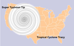

That's 1979's super-typhoon Tip, a bit less than half the size of the contiguous United States.
Secondly they can develop very high wind speeds. In 1996 Severe Tropical
Cyclone Olivia had a wind gust measured at 253mph, the world record
non-tornadic wind speed.