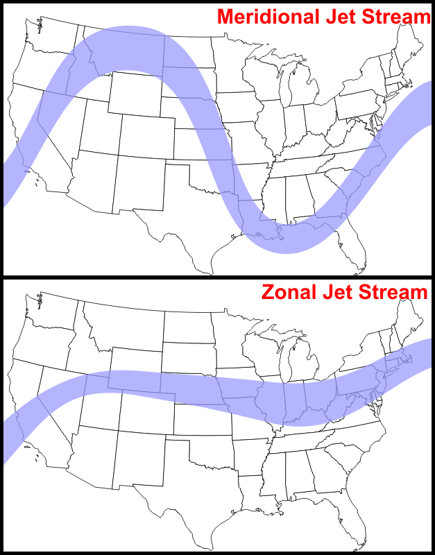
For moneymaking opportunities in natural gas the main effect to look for is descending cold air disrupting the polar vortex and changing the jet stream from a zonal pattern which contains the cold in the arctic to a meridional pattern which allows alternating tongues of cold and then warm air to pass over a given spot in the northern hemisphere. Here's a map of the two patterns from December last year:
The question, should the SSW occur, is does the cold air go to North America or Europe/Eurasia.
Because the meridional pattern alternates warm/cold it is not a one-way bet but instead can set up a long-short-long sequence if 1) you get the correct area for the event and 2) you get the first trade right.
Very tricky in practice.
And from Severe Weather EU:
A warming event high up in the Stratosphere is looking likely to unfold at the start of the new year 2021. Stratospheric warming events in winter, are very important, as they can change the course of winter weather development and affect global circulation.
The “main actor” in these powerful events, is of course the Polar Vortex. It connects the bottom of the atmosphere (our weather) with the stratosphere above it. A strong exchange of energy between these two layers can shake the very foundations of the weather development across the Northern Hemisphere.
WHAT IS THE POLAR VORTEX?
The atmosphere above us has many different layers. All of the clouds and the weather that we feel are found in the lowest part of the atmosphere called the troposphere. It reaches up to around 8 km (5 miles) altitude over the polar regions and up to around 14-16 km (9-10 miles) altitude over the tropics.Above it, there is a different layer called the stratosphere. This layer is around 30 km thick and is very dry. Pressure values on top of the stratosphere (~52km altitude) are 1000-times lower than on the ground! Unlike in the troposphere, the temperature in the stratosphere increases with altitude. We can see the layers of the atmosphere on the image below, with the stratosphere in green hues, and the troposphere in blue at the bottom. The red line nicely shows the temperature progression with height above Earth.

Every year as we head into autumn, the north pole starts to cool. The solar input to the north pole decreases as the angle of incoming solar rays lowers. Eventually, the solar angle is so low, that no direct Sun rays can reach the north pole. That is known as the “polar night” when the Sun stays permanently below the horizon for a certain period....
....MUCH MORE
Front (February) U.S. futures 2.463 +0.019