Columbia/IRI, along with Australia's BoM have become our go-to quick hits for the El Niño-Southern Oscillation. For the deeper dives, we consult the NOAA in the U.S. and Japan's "Japan Agency for Marine-Earth Science and Technology" (JAMSTEC).
JAMSTEC defined the modoki flavor of El Niño which arises in the central rather than the eastern Pacific with the Japanese word meaning "similar but different", handy for dropping casually into conversation at the Thursday afternoon salon.
From Columbbia/IRI, December 19:
IRI ENSO Forecast
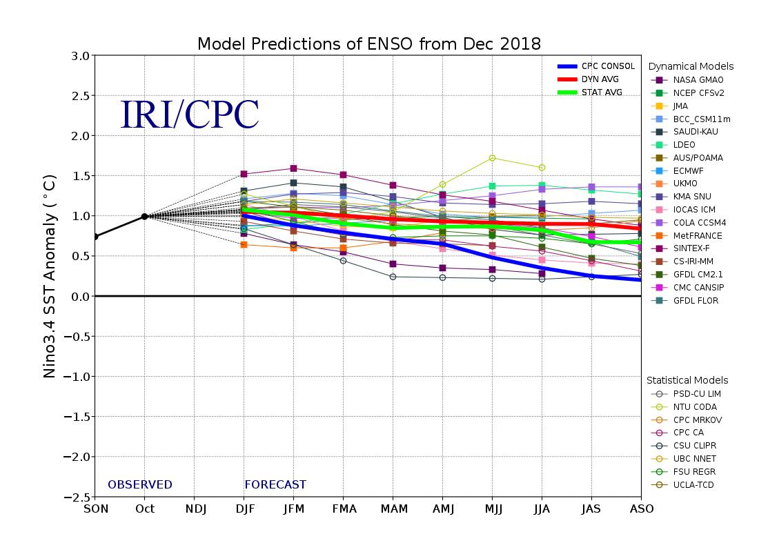
IRI/CPC ENSO Predictions Plume
Published: December 19, 2018
Note on interpreting model forecasts
The following graph and table show forecasts made by dynamical and statistical models for SST in the Nino 3.4 region for nine overlapping 3-month periods. Note that the expected skills of the models, based on historical performance, are not equal to one another. The skills also generally decrease as the lead time increases. Thirdly, forecasts made at some times of the year generally have higher skill than forecasts made at other times of the year--namely, they are better when made between June and December than when they are made between February and May. Differences among the forecasts of the models reflect both differences in model design, and actual uncertainty in the forecast of the possible future SST scenario.

Because of occasional data corrections and late model runs following the time of ENSO product issuance, the data shown in the ENSO forecast table and the ENSO plume graph may not always match. The best source of the ENSO forecast data is http://iri.columbia.edu/~forecast/ensofcst/Data/ensofcst_ALLtoMMYY where MM is the month number and YY is the year...MUCH MOREAnd from Australia's Bureau of Meteorology, December 18:
If interested see also: "IRI ENSO Forecast 2018 December Quick Look" and "December 2018 Climate Forecast Discussion for Jan-Mar 2019 through Apr-June 2019"
ENSO Wrap-Up
Current state of the Pacific and Indian oceans
Warm Pacific Ocean but no corresponding change in weather & climate patterns
The El Niño–Southern Oscillation (ENSO) remains neutral, despite ocean temperatures being at El Niño levels. The Bureau's ENSO Outlook remains at El Niño ALERT...MUCH MORE (use navigation tabs at top of discussion)
The term El Niño–Southern Oscillation refers to the interaction between the tropical Pacific Ocean ("El Niño") and its overlying atmosphere ("Southern Oscillation"), which together produce a global influence on weather and climate. While tropical Pacific sea surface temperatures (SSTs) are currently at El Niño levels, atmospheric indicators—such as cloudiness, pressure patterns, the Southern Oscillation Index (SOI) and trade winds—have generally remained neutral.
This means that the ocean and atmosphere are not reinforcing each other, known as coupling. It is this coupling that defines and sustains an ENSO event, and results in widespread shifts in global weather and climate.
The natural seasonal cycle of tropical Pacific SSTs and cloud means that the likelihood of an ENSO event developing during mid-summer is lower than at other times of year. This is because the difference in SSTs across the Pacific Basin eases towards a minimum in late summer to autumn. Late developing El Niño events do occur, such as in 2006–07 and 2009–10, although there is no record of one starting in January.
Most models indicate SSTs in the tropical Pacific Ocean are likely to remain near or above El Niño levels until at least the middle of 2019. However, models typically have less skill when forecasting through autumn. If SSTs did maintain their current anomalous warmth through summer, it would increase the chance of El Niño emerging in 2019.
The positive Indian Ocean Dipole (IOD) event has ended, and neutral IOD conditions prevail. The IOD typically has little influence on Australian climate from December to April.