La Niña Forecast to Stick Around Until June, Long Enough to Exacerbate Some Drought Effects
From IRI/Columbia University, April 14:
IRI/CPC ENSO Forecast
April 2022 Quick Look
A monthly summary of the status of El Niño, La Niña, and the Southern Oscillation, or ENSO, based on the NINO3.4 index (120-170W, 5S-5N)
In mid-March, Sea Surface Temperatures remain below-average
(strengthening slightly) in the central-eastern equatorial Pacific. The
evolution of key oceanic and atmospheric variables is consistent with
continued La Niña conditions, and therefore, a La Niña Advisory remained
in place for March 2022. A large majority of the models in the plume
predict SSTs to stay below-normal at the level of a weak La Niña until
Apr-Jun, and then return to ENSO-neutral levels in May-Jul 2022. Similar
to the most-recent official CPC/IRI ENSO Outlook issued on March 10,
2022, this objective model-based ENSO outlook also predicts a
continuation of the La Niña event with high probability during Apr-Jun....
This has been the longest and deepest La Niña in over a decade:
Meaning the precipitation and temperature effects associated with La Niña will not be ameliorated by a sudden flip to El Niño.
From Climate.gov, March 10, 2022:
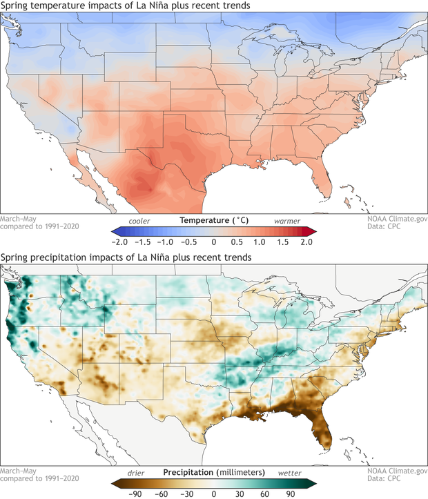
...The images below show the average March-May temperature and
precipitation patterns we’d expect based on the combination of
historical La Niña patterns and recent (10-15 year) climate trends.
March-May
average temperature (top) and precipitation (bottom) compared to the
long-term average for the combination of historical La Niña events and
climate trends. Data is based on the CPC ENSO composites and modified by Climate.gov.
As one might expect, NOAA CPC’s official seasonal outlooks for March-May 2022
resemble the patterns above with some exceptions. In general,
above-average temperatures are favored over a large part of the
contiguous U.S., with the exception of the northwestern U.S., where
below-average temperatures are more likely. Above-median precipitation
is expected over the northwestern U.S. and the Ohio and Tennessee
valleys. Below-median precipitation is favored over most of the southern
U.S., extending northward into Utah, Colorado, and parts of the western
Great Plains (footnote #1).....