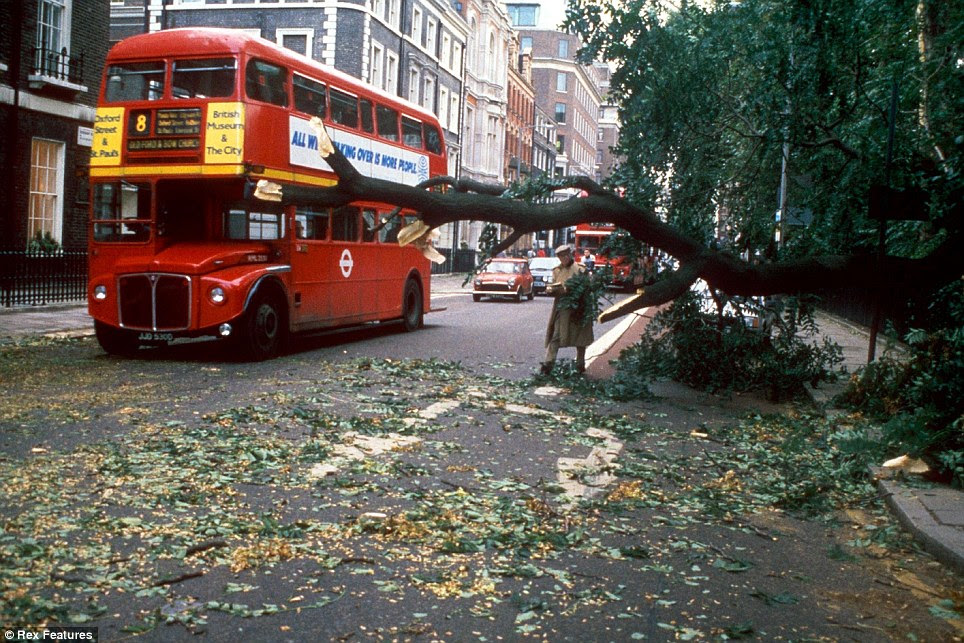
A quick look back at the Great Storm of October 15 - 16, 1987 and how the lack of a pressure release by the London market that Friday exacerbated what came on October 19.
First up, Norwich's Eastern Daily Press
1987 storm: How the chaos contributed to Black Monday financial crisisPublished: 6:00 AM October 15, 2012 Updated: 9:26 AM October 10, 2020
To add to the chaos created by the October 1987 great storm, the extreme wind and rain contributed to a shocking global financial crisis.
The storm played its part in making what came to be known in the financial world as Black Monday.
With an estimated 15 million trees blown down by gales of over 90mph in the south-east of England, the timber market was all of a sudden flushed with stock that threatened to see the trade's worth plummet.
To combat this great stores of wood were safely stored in mass piles, including at Thetford Forest where 173,000 cubic metres of felled timber was stored.
In total there was an incredible 600,000 cubic metres of woodland lost in Norfolk and Suffolk.
The financial markets felt an unfortunate knock-on effect of the storm however, with the travel problems and loss of power for many homes meaning that few traders managed to struggle into work in London on Friday, October 16.
Unfortunately this coincided with the Hong Kong and Tokyo stock markets crashing and the financial crisis spreading west through Europe.
When London re-opened on Monday, October 19, there was mass panic selling of stocks....
....MUCH MORE
Trees.
It seems that trees loom large in the collective memory.
Almost every account mentions the trees. Gorleston Norfolk had a 122 mph wind gust.
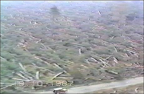
The pics are...amazing:


Suffolk- A car drives past a forest devastated Kent
by the Great Storm of 1987, with a single tree
left standing.
In an October 2013 piece, "Tale of Two Storms" which compared the effect of the '87 blow with a similar storm, were it to repeat now, the Financial Times noted:
...A green and pleasant landThey go on to note that the forests of London the last few years have been comprised of construction cranes.
The Kent town of Sevenoaks is named after the seven oak trees that were planted there in 1906. In 1987 six of them were blown over, along with about 15m other trees across the UK. The storm’s impact on England’s trees – from forests to copses – is deeply ingrained in its cultural legacy. Today there are 6.2m hectares of woodland in the UK, says the Forestry Commission. Pests that affect trees – such as the horse chestnut leaf miner – have spread in recent years. In 2012, the Forestry Commission warned of an “unprecedented level of threat” from pests and diseases that may weaken trees. But one of the biggest factors determining the number of trees Britain could lose this time will be – as it was in 1987 – how wet the soil is in which they stand. Falling trees posed a major problem for power and telephone lines in 1987, while this time the sturdiness of mobile masts will also come into play....
So, we have the answer to the age-old question, if 15 million trees fall, everyone notices. And remembers.
With that we get to our headliner.
Writing for the Royal Meteorological Society, Bob Prichard has what is probably the most accessible piece of scholarship of the events:
Research Article
The Great Storm of 16 October 1987
First published: 26 September 2012
Abstract
This Special issue commemorates the 25th anniversary of one of southeastern Britain's most violent weather events of the twentieth century. The first half of the issue looks at the development and impact of the storm, including how woodlands were affected – an aspect that was widely misunderstood at the time. In the second half we explore further the lessons that were learnt by meteorologists, with particular reference to what threatened to be a possible repeat last December. We also include an article on a localised historical tornado from the same time of year. October 1987 was not short of remarkable weather, and nearly always the cause was a deep, sharpening upper trough to the southwest of Britain. Very cold air plunging southeast over warm seas triggered vigorous depressions, whilst blocking high pressure over eastern Europe meant that the slowing and sharpening of the troughs gave further impetus to the depressions and also drew up some very warm, moist air in the warm sectors.
The days following the 1987 storm were uncomfortable ones for forecasters: put simply, the event was just not forecast (at least on the day – it had been signalled a few days earlier). It was, therefore, heartening to read in a Met Office Press Release dated 12 October 1988 and headed ‘The Storm of 1987 – one year on’: Extraordinary weather sequences such as those which caused last year's October storm are being overcome by the Met Office's development programme. Problem solved! (This extract appeared in the January 1989 issue of Weather, page 11).
Setting the scene
This was a recipe for copious rainfall, and it was repeated several times during the month. On the night of 15/16 October it also had the effect of producing a violent storm as an already very deep depression moving northeast over Biscay deepened further over the warm sea and in response to the sharpening of its governing upper trough. The depression was a complex feature, with several small offshoots running northeast ahead of it along its warm front.
Figures 1-4 illustrate the run-up to the event. From 12 to14 October the baroclinic zone, depicted by the extensive cloud south of 50°N, is fairly smooth with little apparent development. In the 80-page Special issue that Weather published on the storm, Monk and Bader (1988) remarked that this cloud band extended from the vicinity of hurricane Floyd near Florida. Development of the storm is clearly well underway by late afternoon on the 15th (Figure 4); Monk and Bader discussed the development of the cloud head and dry wedge, both becoming apparent in this image and features known to precede intense cyclogenesis.
A quiet evening followed by a night of mayhem
A very marked temperature contrast developed across the warm front as it edged erratically into southeast England during the late afternoon of the 15th; at 1700 utc, the temperature was 16°C at Herstmonceux (East Sussex) and 9°C at Heathrow. For a while in the evening events ‘marked time’ as a ripple ran along the front, keeping the warm air just over the extreme southeast and the Channel Islands: it was windy in the warm sector, but not excessively so. By 2200 utc, the temperature was 8°C at Stansted and 17°C at Southend (both in Essex). Around this time there was a rapid fall in barometric pressure at the western end of the warm sector, over northwest France, and little change in pressure over northeast France. This was soon reflected in a marked strengthening of the wind along a track about 70km wide, which reached the Channel Islands around 0000 utc on the 16th. The central pressure of the depression at this stage was about 953mbar just north of Brest.
Amongst the less remarked-on effects of the night was the amount of dirt deposited on all surfaces as the temperature suddenly rose on the passage of the warm front, creating condensation on all surfaces – such as the outside of windows. There was at least a fair amount of dry weather in the warm sector following hours of warm-frontal rain.
By 0200 utc, the violent winds had reached all of the south coast from east Dorset to East Sussex...
.... MUCH, MUCH MORE
Here's some guy* writing at The Guardian about the April 2000 leg of the dotcom crash on the London exchange and looking for a comparison:Meltdown at the stock exchange*Okay, not just "some" guy.
...Such paralysis has never been witnessed before in the London market, the closest example being October 16 1987, when the hurricane resulted in so few City workers getting to their desks that the exchange shut early. The following week, the stock market suffered its biggest fall in living memory - Black Monday....
That's Paul Murphy in a prior life before he went on to fame and fortune, becoming a honcho at the Financial Times and the tough-but-fair boss at FT Alphaville and then FT Investigations.