This doesn't mean it will be warm, winter is winter, but the odds are for more of a Jimmy Carter "Put on a sweater" winter rather than a skating on the canals or Ice Faire on the Thames type of winter.
Those should return in 2028.
From SevereWeatherEurope, September 25:
*Winter forecast 2021/2022* First look at Winter reveals a shift in the jet stream due to the new La Nina, felt in North America and in Europe
*****
.....WINTER SEASON 2021/2022 MODEL FORECAST
We now know what La Nina is, and how it can change the jet stream and the weather. Now we will take a look at the global long-range models, and how they see the developing Winter 2021/2022.
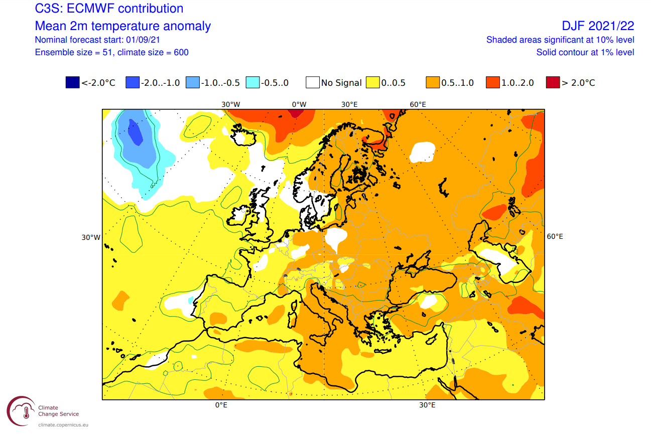
We decided to focus on the 3 main (or most used) seasonal models. The ECMWF and UKMO from Europe, and the CFSv2 from the United States. Graphics are from the Copernicus Climate EU project and the CPC/NCEP.
All these forecasts are an average picture over the course of 3 meteorological winter months (December-January-February) and show the general prevailing weather patterns. Even if the models would be completely accurate, it does not mean that such weather conditions would last for 3 months straight. It only suggests how the weather patterns might look 40-60% of the time.
ECMWF WINTER FORECAST
The ECMWF model is most often referred to as the most reliable model, at least in the long-range category. In reality, a lot depends on the individual situation and individual seasons. But generally, the ECMWF model is at the top of the chart as far as reliability goes. But no long-range/seasonal forecast can ever be deemed “reliable“. We are only looking at trends and how the weather patterns might evolve over the entire continents or the planet.In the pressure pattern forecast from ECMWF below, we can see the strong high-pressure system in the North Pacific, typical for a La Nina. The low-pressure system is developed over eastern Canada and the jet stream is bending in between the two pressure systems, just like we have seen in the previous segment.
We also see the North Atlantic in a positive NAO mode, which means an amplified jet stream over the British Isles and into Scandinavia. But this is not a typical positive NAO setup, as it is more west-oriented. It allows for winter situations over Europe. Most likely if the high-pressure system in the central Atlantic can crawl further up north, blocking the jet stream and creating a more northerly flow into Europe.
*****
Europe also features higher than normal temperatures, but not to a high degree. Tho a more westerly flow dominant scenario is suggested, the pressure pattern does allow for a break in the flow. Occasional cold flow from northwest Europe is possible down into the mainland.
Looking closer at Europe, we see the surface temperatures are mostly above normal. Higher temperature anomalies and milder conditions are more likely towards the eastern regions. Central and western regions are likely to see occasional cold fronts from the northwest, hence the lower magnitude anomaly.
.....MUCH, MUCH MORE
The 2m anomaly is the modeled divergence from average for temperature taken at two meters.