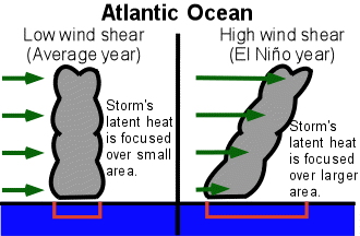
(see NOAA)
The largest change is in decreased wind shear which allows more storms to spin up. There are additional teleconnections that affect steering winds and even some hypothesized changes in sea surface temps. See below.
And today's blurb, from Reuters:
An area of low pressure located east of the Lesser Antilles now has a high, or 70 percent, chance of becoming a tropical cyclone during the next 48 hours, the U.S. National Hurricane Center (NHC) said in its latest advisory on Monday.*NOAA Changes El Niño Forecast From "We're All Gonna Die" to "Weak to Moderate"
"Only a small increase in organization of shower activity would result in the formation of a tropical depression as the system moves westward to west-northwestward at 15 to 20 miles per hour during the next day or two," the Miami-based weather forecasters said.
From the University of Illinois:
| Atlantic | Eastern Pacific | |||
|---|---|---|---|---|
| Average | El Niño Avg. | Average | El Niño Avg. | |
| Named storms | 9.4 | 7.1 | 16,7 | 17.6 |
| Hurricanes | 5.8 | 4.0 | 9.8 | 10.0 |
| Intense Hurricanes | 2.5 | 1.5 | 4.8 | 5.5 |
