The Norwegian Petroleum Directorate is readying to map potential deep sea mineral deposits in the Norwegian Sea, with an expedition due to get underway this month.Meanwhile, at the other end of the Northern Sea Route, also via Maritime Executive:
The Directorate has engaged Swire Seabed, which partners with Ocean Floor Geophysics, to carry out mapping of potential sulfide minerals on the seabed over the Mohns Ridge in the western Norwegian Sea. This is a spreading ridge in the Atlantic Ocean that separates two oceanic plates, where potential valuable minerals have been formed through hot volcanic sources. The focus of the expedition is not the active hydraulic systems such as “black smokers,” but rather non-active extinct systems that are now left as mineral-rich piles of gravel on the seabed.
The mapping will be carried out using an autonomous underwater vehicle, a Kongsberg Hugin AUV, which will map the seabed using a bottom-penetrating echo sounder, multibeam bathymetry, synthetic aperture sonar data, magnetometry and spontaneous potential field data.
After the data is processed on board, mineral samples will be taken from the seabed where the data indicates the presence of deposits. Sampling will be carried out using an underwater remotely operated vehicle with a depth capability of 3,000 meters (9,800 feet).
Earlier studies by the Norwegian Research Council have indicated that the region could contain resources worth as much as $110 billion. Around 6.4 million tons of copper metal in addition to zinc (6.5 million tons), gold (170 tons) and silver (9,901 tons) have been estimated to be present in the region....MORE
Dredging for Gold in the Bering Sea
The snow has thawed enough for the gold dredging season to kick off, and dredgers in Nome, Alaska, are ready to be on the water in search of hidden treasures on the Bering Sea floor. With boats in the water and deckhands aboard, these gritty and independent men and women are ready to hit the season hard in hopes of finding their lucky cache.I still have trouble wrapping my head around the Nome gold rush.
However, before these pioneers can seek out their awaiting treasures on their unique vessels, they must first obtain an inspection from the U.S. Coast Guard. An approved Coast Guard vessel inspection is also required by the Department of Natural Resources in order for dredgers to obtain a seasonal permit to dredge in Nome. They are off to a later start than usual this year, which made for a bustling week of inspections that picked up steam as the week went on...MORE
Compared to the horrors of walking to the Dawson/Yukon/Klondike gold rush:
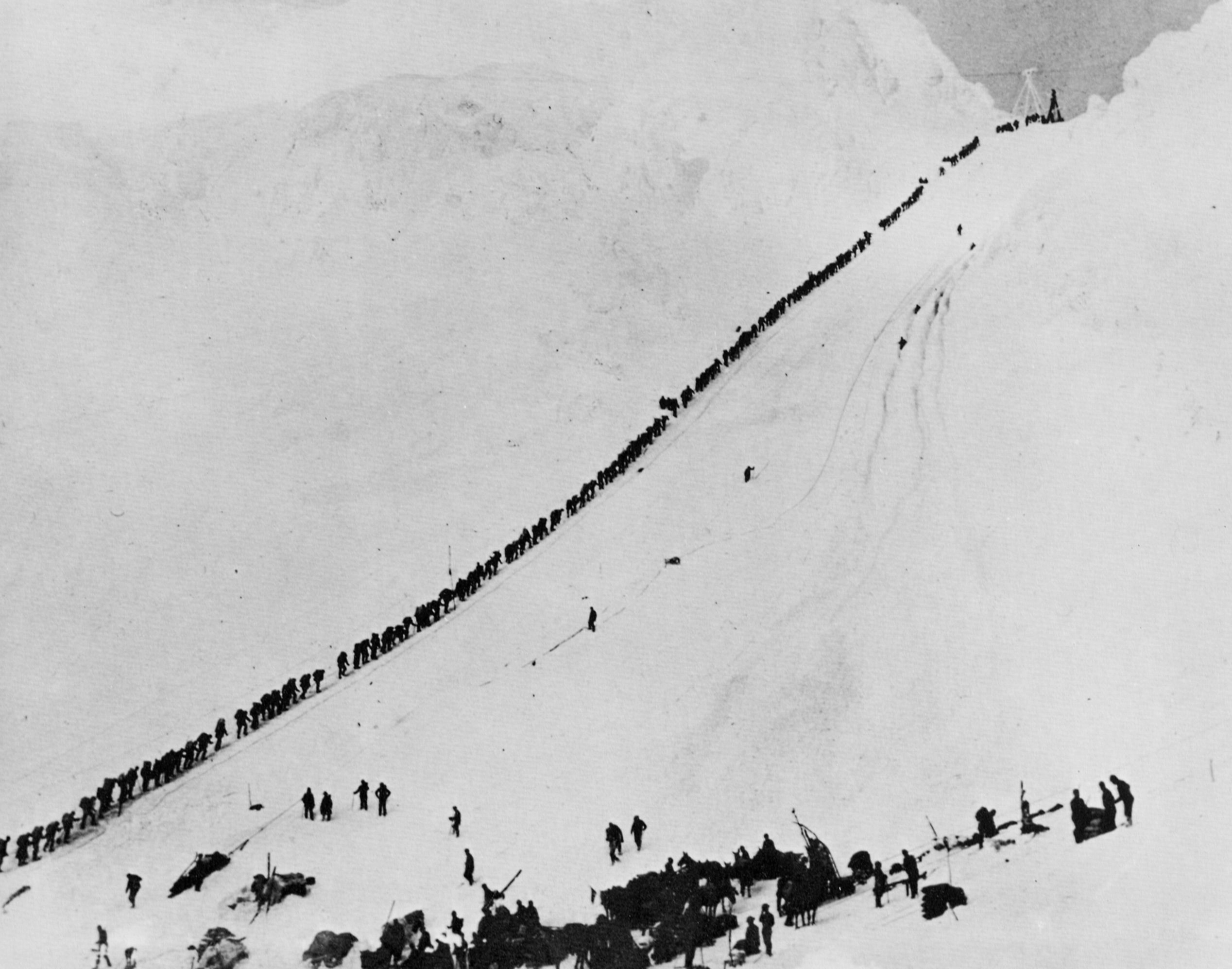
Where most of the 100,000 or so adventurers struck out completely and those that did find some 'color' suffered freezing in the winter and mosquitos in the summer along with backbreaking labor to vary the misery, the discovery of gold at Nome was a day at the beach.
From Wikipedia:
The Nome Gold Rush was a gold rush in Nome, Alaska, approximately 1899–1909.[1] It is separated from other gold rushes by the ease with which gold could be obtained. Much of the gold was lying in the beach sand of the landing place and could be recovered without any need for a claim....Although some who had come up the Dawson trail and failed ended up crossing Alaska along the Yukon river, other later arrivals took ships up from Seattle which deposited them at the beach.
