If some idiot San Franciscan fleeing the urban hellscape sets the Lake Tahoe 'hood on fire I'm going to be pissed.
From Priceonomics, October 14, 2020:
This post is from Cape Analytics, a Priceonomics Data Studio customer. Does your company have interesting data? Become a Priceonomics customer.
***
As the world is still in the midst of a global pandemic, we are now entering fire season in the American West. After years of elevated global temperatures and drought, by the end of each summer, smoke-filled skies seem to be the norm across the West.
Though we would love a respite from calamity, there is no reason to believe that we’ll be spared from wildfires this year. With scientific certainty, we know which areas are prone to wildfires, though home construction continues in those areas.
At Cape Analytics, we use artificial intelligence to analyze vast quantities of geospatial imagery to help insurers and other companies better understand properties and property risk. Along with our partner HazardHub, we wanted to explore exactly how much sprawl there has been in the West’s high-risk fire zones. From the standpoint of insurance and danger to human life, these homes and adjacent communities are especially risky. Quantifying the risk can help homeowners and agencies such as CAL FIRE take more proactive and focused measures to protect lives and property.
The Hot Spots
To create this report, we analyzed new homes built over the last decade and found that California leads the West when it comes to the most builds in high-risk areas. Given that California is the most populous state in the country, we can expect a lot of new construction. When adjusting for population size, Utah leads the West by a significant margin in building homes in places with high fire risks.
When looking at specific cities with the most new home construction in high-risk zones in the West, El Dorado Hills, California tops the list, followed by St. George, Utah. In addition, as the pandemic has precipitated an urban exodus, many residents are fleeing into higher-risk fire zones.
Research Strategy
Before diving into the analysis, it’s worth spending a moment on the data and methodology. In this project, we identified new home construction over the last decade in Western states prone to wildfires. Specifically, we focused on areas in or near the Wildland Urban Interface — areas designated by the U.S. Forest Service, where human development and fire-prone wilderness meet. Our hazard data partner, HazardHub, then provided us with a wildfire risk score for each locality. This risk score takes weather, wildfire history, and many other factors into account. Finally, we narrowed down our analysis to new homes built in those high wildfire risk zones.
Findings by State
First, let's look at the raw number of new homes built in the last decade in high wildfire risk zones out West:
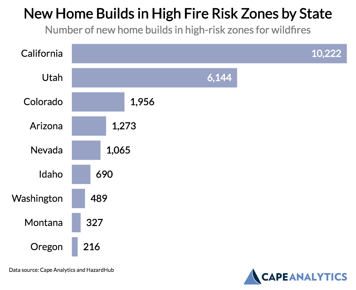
Source: Cape Analytics
Over the last decade, California has built over 10,000 homes in areas deemed as high wildfire risk. High land prices and stringent zoning requirements in the California urban core have pushed builders further into rural areas, where the fire risk is much higher. Over the last few years, we have seen how dangerous wildfires can be in these areas of California, as places like Paradise and Santa Rosa have been devastated by fires. Among Western states, Utah ranks second in terms of high fire risk building, followed by Colorado.
However, it’s important to remember that California is the largest state in the United States by population and the third-largest by landmass. Given its size, we can expect more home construction in California compared to other states.
To account for this size question, we’ve adjusted by population, to see where states are building more homes in wildfire zones at the highest per capita rate (per 100,000 residents):....
....MUCH MORE
If interested see also September 2014's "California: The Last 200 Years Were The Happy Time For Weather, Get Ready For A Return to The West Without Water"
And as noted in the outro from a 2018 post:
....What follows are some historical comparisons with a couple caveats:
1) the further back in time you go the less precise/reliable the size of the burn area. Death statistics tend to be more accurate.As people move into formerly wild areas they cause a higher percentage of fires versus lightning. On the other hand fires that formerly burned until they ran out of fuel or until the rains came are now battled aggressively.....
2) Because of dramatic land use changes the dynamics of number of fires and extent have changed.
And 2019's "Wildfire: "Insurers Trim Their Risks in California"":
Speaking of fire insurance.Wires in the wood, no good....
We've talked about how wildfire risks multiply simply by having more and more and more people living in previously wild or semi-wild areas.
Then when you run electricity into these areas that are no longer allowed to burn naturally, when the wires break and the land does catch fire, you have a disaster on your hands....