From Category 6:
Here comes trouble. Hurricane Irma built an eyewall over the warm waters of the Eastern Atlantic on Thursday morning, and is now rapidly intensifying, becoming a Category 2 hurricane with 100 mph winds at 11 am EDT. Irma is the fourth hurricane of this active Atlantic hurricane season, and comes three weeks before the usual September 21 date for the season's fourth hurricane. Irma appears destined to become a dangerous long-track major hurricane that could potentially impact the islands of the Caribbean as well as the mainland U.S. next week and the following week.
Satellite images on Thursday morning showed a well-organized storm with plenty of heavy thunderstorms which were increasing in intensity, and a prominent eye had appeared in both visible and infrared imagery. Irma had a respectable upper-level outflow channel to the south, and a weaker one to the north. Conditions were favorable for development, with sea surface temperatures (SSTs) near 27.5°C (82°F)—more than 1°C above average, light wind shear of 5 -10 knots, and a moist surrounding atmosphere with a mid-level relative humidity near 65%.
Intensity forecast for Irma
For the next five days, wind shear is predicted to be very favorable for development--a low 5 – 10 knots--according to the 12Z Thursday run of the SHIPS model. In fact, SHIPS keeps wind shear at less than 5 knots from Thursday afternoon into Saturday. Irma will begin moving into a drier region with slightly cooler sea surface temperatures beginning on Thursday night. Friday through Sunday, SSTs will be 26.5 – 27.5°C (80 - 82°F), and the mid-level relative humidity will be 50 – 55%--conditions that are less favorable for development. Since Irma has already built a solid inner core, it should be able to overcome these less favorable conditions and continue to intensify at a slow to moderate pace. If the storm can develop upper-level outflow channels to both the north and the south, faster intensification may occur.
Early next week, when Irma will be approaching the Lesser Antilles Islands, SSTs will warm considerably with a major increase in total heat content. The atmosphere is also predicted to be moister with low shear, so increased strengthening is likely. Four out of five of our reliable intensity models--the HWRF, LGEM, COAMPS-TC, and DSHIPS--predicted in their 6Z and 12Z Thursday runs that Irma would be a major Category 3 or 4 hurricane with 115 – 135 mph winds by Tuesday. The official NHC forecast of a Category 4 hurricane in five days looks reasonable, given Irma's current rapid intensification burst....

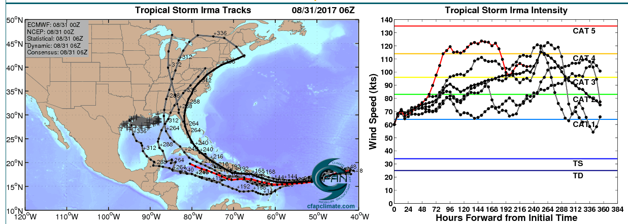
Figure 2. Left: The adjusted 0Z August 31, 2017 track forecast by the operational European model for Irma (red line), along with the track of the average of the 50 members of the European model ensemble (heavy black line), and the track forecasts from the “high probability cluster” (grey lines)—the four European model ensemble members that have performed best with Irma thus far, as of 6Z Thursday. Right: the corresponding intensity forecast for these various model runs, with the operational European model forecast shown in red. All of the forecasts take Irma to major hurricane status at some point in the next 12 days. Irma is much stronger than the 0Z run had anticipated, so the intenisty forecast is likely underdone. Image credit: CFAN....MUCH MORE