August 25, 2017, 2:34 PM
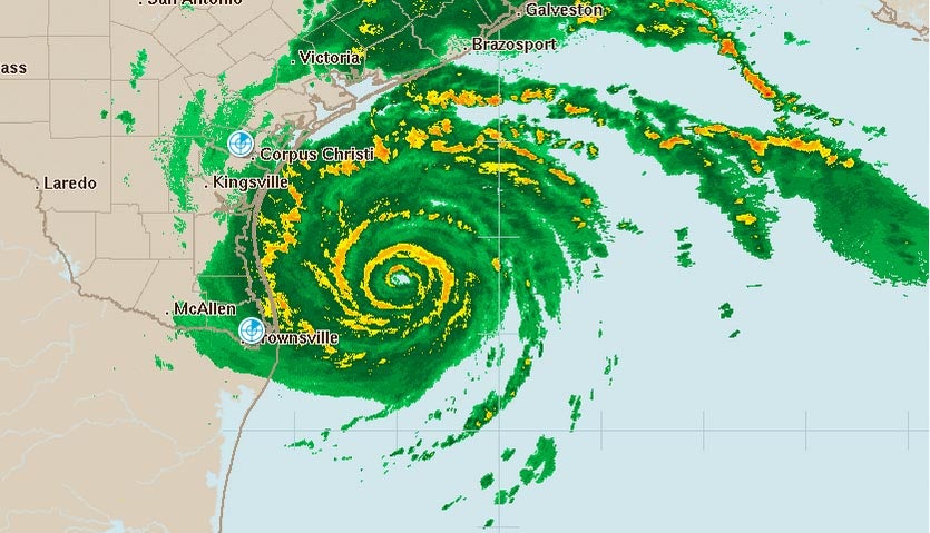
Hurricane Harvey is poised to deliver a catastrophic flooding blow to Texas after putting on an impressive round of rapid deepening Friday morning that brought the storm to the verge of Category 3 strength. Harvey passed over a warm ocean eddy with high heat content for over 6 hours Friday morning, and the extra energy the eddy provided allowed Harvey’s central pressure to fall a spectacular 15 mb in just two hours, from 967 mb at 4 am CDT to 952 mb at 6 am CDT. It takes several hours for a hurricane’s winds to respond to a rapid pressure fall, so we can expect that Harvey will be a Category 3 hurricane with 120 mph winds by Friday evening. An Air Force hurricane hunter aircraft in the storm this morning was continuing to see falling pressures, with the 8 am CDT eye penetration recording a 949 mb pressure. The aircraft also observed evidence that an eyewall replacement cycle was beginning. In this situation, the inner eyewall would collapse and be replaced by a new eyewall with a larger diameter, which would likely slow down or end Harvey’s intensification phase.

Harvey is a very dangerous hurricane with extreme winds, storm surge, and rainfall. If you live in Texas, please heed the advice of local emergency management officials, and get out immediately if you live in an evacuation zone. Heavy rain squalls and strong wind gusts are already affecting the Texas coast, and tropical storm-force winds will begin affecting portions of the coast late Friday morning or early Friday afternoon, making evacuation difficult.
Favorable conditions for intensification continue
Conditions in the Gulf of Mexico on Friday morning continued to be very favorable for intensification. Satellite images and radar showed that Harvey had expanded in size, and had a very impressive area of heavy thunderstorms with well-organized spiral bands that were dumping torrential rains. Harvey had an intense ring of very heavy thunderstorms surrounding a 13-mile diameter eye, and cirrus clouds streaming away from the center showed the presence of excellent upper-level outflow to the north and east, which was ventilating the storm and allowing intensification to occur. Wind shear was light to moderate, 5 – 15 knots, and the atmosphere had a high mid-level relative humidity of 70%. Sea surface temperatures (SSTs) were a very warm 30°C (86°F). Warm waters extended deep into the ocean, providing a large reservoir of heat for the storm to draw upon....MUCH MORE
...Harvey’s combination of strength and rainfall duration has few if any parallels
The historical record of U.S. hurricanes gives us few, if any, analogs for a major hurricane landfall that transitions into a multi-day rainfall event as prolonged, extensive, and intense as the scenario painted by multiple forecast models for Harvey. All four of the high-probability 0Z Friday European model ensemble members, and all but one of the 20 GFS members, maintain Harvey at Cat 1 strength (or better) for the next five days.
The official NHC forecast on Friday morning called for Harvey to maintain tropical storm strength through Wednesday. Even after Harvey weakens below hurricane strength, gale-force winds will continue to pump vast amounts of moisture onshore, fueling several days of heavy rain. The latest 5-day precipitation outlook from the NOAA/NWS Weather Prediction Center (see Figure 3) projects that an area larger than the state of Massachusetts, including Houston and Galveston, can expect more than 20” of rain between now and Wednesday. Amounts of more than 10” cover an even larger area, extending into parts of the Austin-San Antonio urban corridor and including Corpus Christi and Beaumont-Port Arthur, TX, and Lake Charles, LA. Very serious flooding over the next several days can be expected well inland from the areas immediately at risk from Harvey’s initial landfall and storm surge. For example, Austin/San Antonio NWS office notes the potential for life-threatening flash flooding, especially from San Antonio south and east....