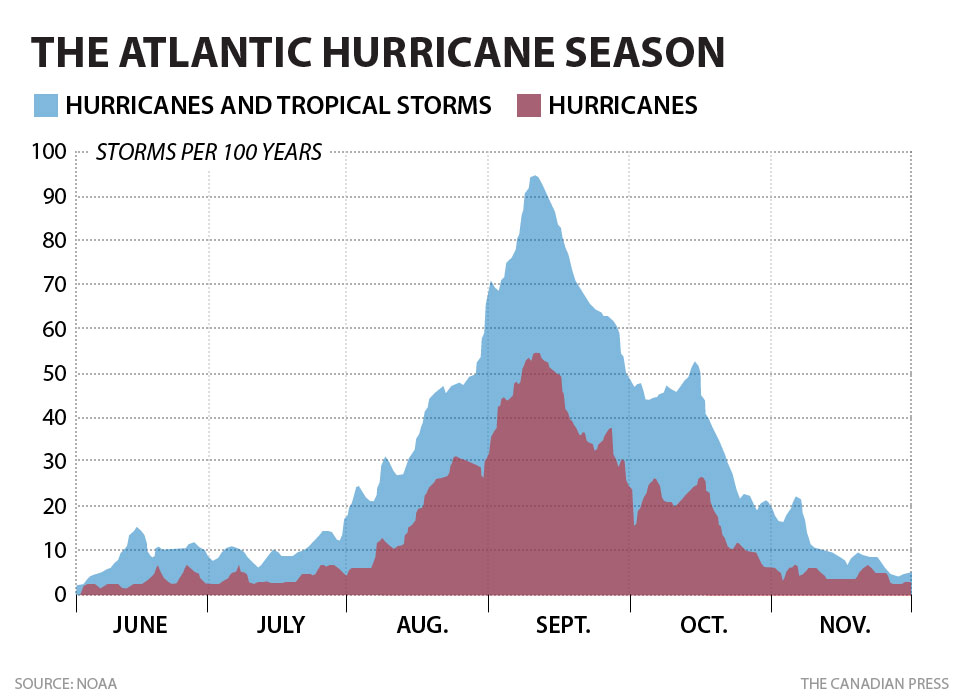
The bad news is: It's a long season:

NOAA had forecast an average to slightly below average season.
First up, the Baltimore Sun:
With tropics quiet, hurricane season could get latest start since 2004
The tropics are quiet nearly a month into the Atlantic hurricane season, and that could eventually mean the season's latest start since at least 2004. No tropical cyclones have formed yet this year, whereas in each of the past nine years, a tropical storm has developed in May or June.And from Wunderblog:
The National Hurricane Center does not forecast any cyclone development within the next 48 hours, and there are no areas it is eyeing for storm development within the next five days, either. Last year, Tropical Storm Andrea formed June 5, while in 2012, Tropical Storm Alberto came before the season's official June 1 start, on May 19. In 2011, tropical storm Arlene formed June 28, a mark we are sure to surpass this weekend. It has been since 2004 that a named storm did not develop until July -- and Hurricane Alex, in that year, didn't form as a tropical storm until July 31.
Though that season got a late start, it was nonetheless a costly one, including hurricanes Charley, Francis and Ivan. Strong wind shear, which occurs when wind speeds and directions vary at different altitudes, has been the strongest factor inhibiting storm development, AccuWeather.com hurricane expert Dan Kottlowski said in a post Wednesday. AccuWeather notes that there have been 1-2 storms in May and June in each of the past nine years, except 2012, when there were four in that period. On average, going back to 1966, the first Atlantic tropical storm doesn't form until July 9, however. The first hurricane forms by Aug. 10, on average, and the first major hurricane doesn't typically form until Sept. 3....
91L Near Tropical Depression Status; Entire SE U.S. Coast Could be Impacted
An area of disturbed weather over the warm waters of the Gulf Stream, located about 130 miles east-northeast of Melbourne, Florida on Monday morning (Invest 91L), has grown more organized this morning. Surface pressures are falling, and 91L is close to tropical depression status. Satellite loops on Monday morning showed 91L had a well defined surface circulation, with heavy thunderstorms building and steadily organizing into spiral bands. Long-range radar out of Melbourne, Florida showed these bands were already affecting the coast of Central Florida. Sea surface temperatures in this region were about 1°C above average, 27 - 28°C. The counter-clockwise circulation of an upper level high pressure over Florida was bringing northerly winds over 91L at high altitude, and these winds were creating light wind shear of 5 - 10 knots. However, water vapor satellite loops show that the atmosphere has dried noticeably to the north of 91L since Sunday, and the northerly winds are driving this dry air in the heart of the storm. This dry air is interfering with development and keeping any heavy thunderstorms from developing on the north side of the circulation. The Hurricane Hunters will investigate 91L on Monday afternoon.
Figure 1. Water vapor satellite image of 91L taken at 10:45 am EDT Monday June 30, 2014. A large area of dry air (black colors) was to the north of the system, and was interfering with development. Image credit: NOAA/NESDIS.
Figure 2. Wind forecast for 11 am Thursday, July 3, 2014, as made by the 06Z Monday June 30, 2014 run of the GFS model (left) and 00Z Monday run of the European model (right.) Both models are predicting that 91L will become a tropical storm and threaten the South Carolina coast on Thursday.
Forecast for 91L
Steering currents are weak off of the Southeast U.S. coast, but the models are in good agreement on the track of 91L. The disturbance should continue a slow southward to southwesterly motion on Monday, which would bring the storm very close to the coast of Florida by Tuesday.....MORE


 The Black Hand: The annexation of 1908 helped radicalise Serb
nationalist groups. On March 3 1911, in a Belgrade apartment, Ujedinjenje
ili smrt! – Union or Death! – was formed, the secret society that came to be
known as the ‘Black Hand’.


