The two measures of hurricane intensity are how high the wind speed gets and how low the central pressure gets. Here's the latest from the National Hurricane Center, they use the time zone where the storm is located, in this case Central Daylight Time:
...CENTRAL PRESSURE IN THE EYE OF MILTON HAS FALLEN TO A NEAR RECORD LOW... ...MILTON POSES AN EXTREMELY SERIOUS THREAT TO FLORIDA AND RESIDENTS ARE URGED TO FOLLOW THE ORDERS OF LOCAL OFFICIALS...
7:00 PM CDT Mon Oct 7
Location: 21.9°N 90.4°W
Moving: E at 10 mph
Min pressure: 897 mb
Max sustained: 180 mph
Anything below 900 millibars is an extremely strong storm.
As for wind speeds, most of the cyclone records are for the Pacific where storms from the west coast of the Americas to the date line are called hurricanes and cyclones from the date line to Austral-Asian landmasses are typhoons.
The physics of the kinetic energy at various wind speeds: A doubling of the wind speed results in a 23 or eight fold increase in the energy the wind is carrying. Number go up. Fast.
Three doublings from 25 to 200 mph means you are dealing with 512 times greater power than you face at a reasonably brisk 25mph.Some storms worthy of note. First, Hurricane Patricia on Mexico's Pacific coast in 2015 (headlines as they appeared on the blog):
- The National Hurricane Center Calls Patricia "THE STRONGEST EASTERN NORTH PACIFIC HURRICANE ON RECORD."
- "Stunning, historic, mind-blogging, and catastrophic: Hurricane Patrica Hits 200 mph"
- The Astonishingly Light Damage Caused By Hurricane Patricia
Patricia's max. sustained wind speed eventually reached 215 MPH just before landfall.
....The second story linked to the now sadly deceased Wunderblog—which was replaced at WeatherUnderground by the Category 6 blog [on blogroll at right], hence my blather up top—Wunderblog who noted:
....Patricia the third strongest tropical cyclone in history (by wind)Patricia's 200 mph sustained winds make it the 3rd strongest tropical cyclone in world history (by 1-minute averaged wind speed.) Officially, here are the strongest tropical cyclones in world history, according to the Joint Typhoon Warning Center and the National Hurricane Center (using 1-minute averaged sustained winds):Super Typhoon Nancy (1961), 215 mph winds, 882 mb. Made landfall as a Cat 2 in Japan, killing 191 people.Super Typhoon Violet (1961), 205 mph winds, 886 mb pressure. Made landfall in Japan as a tropical storm, killing 2 people.Super Typhoon Ida (1958), 200 mph winds, 877 mb pressure. Made landfall as a Cat 1 in Japan, killing 1269 people.Super Typhoon Haiyan (2013), 195 mph winds, 895 mb pressure. Made landfall in the Philippines at peak strength.Super Typhoon Kit (1966), 195 mph winds, 880 mb. Did not make landfall.Super Typhoon Sally (1964), 195 mph winds, 895 mb. Made landfall as a Cat 4 in the Philippines.However, it is now recognized (Black 1992) that the maximum sustained winds estimated for typhoons during the 1940s to 1960s were too strong. The strongest reliably measured tropical cyclones were both 10 mph weaker than Patricia, with 190 mph winds—the Western Pacific's Super Typhoon Tip of 1979, and the Atlantic's Hurricane Allen of 1980....
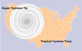
Super Typhoon Tip is also notable for its size:
Those Pacific Ocean storms can get pretty big-
Here's 1979's Super Typhoon Tip:
About half the size of the contiguous United States.
And although it didn't make the sustained wind leaderboard in 1996 Severe Tropical Cyclone Olivia had a wind gust measured at 253mph, the world record non-tornadic wind speed.
More on the Atlantic/Gulf of Mexico records tomorrow but for now a tweet from last year when Hurricane Lee was forecast to reach 180 MPH wind speeds (it didn't, topping out at 165 MPH)
...And from one of the hurricane bigwigs, Colorado State University's Phil Klotzbach
#Hurricane #Lee is forecast to reach a max intensity of 180 mph. Only seven Atlantic hurricanes in satellite era (since 1966) have had max winds >= 180 mph:
— Philip Klotzbach (@philklotzbach) September 8, 2023
Allen (1980), Gilbert (1988), Mitch (1998), Rita (2005), Wilma (2005), Irma (2017), Dorian (2019) pic.twitter.com/P5HOUDFMb3
