From The Independent, July 2:
Catastrophic drought threatens Iraq as major dams in surrounding countries cut off water to its great rivers
Iraq after Isis: After decades of war – including the last battle against Isis – Iraq is in danger of losing the waters of the Tigris and Euphrates. In the first part of a new series, Patrick Cockburn reports that as Turkey, Syria and Iran dam its rivers, parts of the country are turning into desertHT: Naked Capitalism
“I once rescued a friend from drowning when he was swept away by the force of the current as we were swimming in the Diyala river,” says Qasim Sabti, a painter and gallery owner in Baghdad.
“That was 50 years ago,” he recalls. “I went back there recently and the water in the Diyala is so shallow today that a man could walk across it with his dog.”
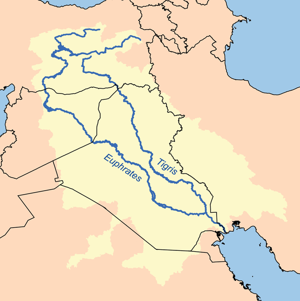
The rivers of Iraq, above all the Tigris and Euphrates, are drying up. The country is becoming more arid, and desertification is eating into the limited amount of agricultural land.
Dams built upriver in Turkey, Syria and Iran since the 1970s have reduced the flow of water that reaches Iraq by as much as half and the situation is about to get worse.
“On 1 July, Turkey will start filling the Ilisu dam on the Tigris and this will cause another decline in the inflows to our country of about 50 per cent,” Hassan Janabi, minister of water resources, told The Independent.
He says that Iraq used to get 30 billion cubic metres of water a year from the Euphrates, but now “we are happy if we get 16 billion cubic metres”....MORE

Turkey is also denying water to northern Syria with dams on the Euphrates.
However, one of the dams, the Attaturk, is the world's third largest and is built directly over the Bozova Fault and is already triggering earthquakes so if it fails Syria may end up getting a lot of water.

This Temblor map shows a satellite image of the Ataturk Dam. Also shown
in this image is the Bozova Fault which runs right underneath the dam.

Also via Naked Capitalism, yNetNews:
Iranian general says Israel stealing Iran's clouds
The head of Iran's Civil Defense Organization claims Israel is 'working to ensure clouds entering Iranian skies are unable to release rain,' insisting this was confirmed by an Iranian scientific study; but head of Iran's meteorological service says 'it is not possible for a country to steal clouds.'...MORE