Just a reminder, New York City sits on a number of seismic faults.
From the hazard mavens at Verisk, August, 3, 2020:
Actually, It Can Happen To Us: The Big One… Hits New York?
Experience can sometimes be the best teacher. While COVID-19 remains a threat for today, the catastrophic impacts that it has wrought may serve as a risk management lesson in the years to come. Human nature may sometimes steer us to dismiss the potential for low frequency/high severity risks. But if the COVID-19 outbreak has taught us nothing else, it is that these once in a generation disasters may be the most important exposures of all.
This article is Part II of the ISO Emerging Issues team’s Actually, It Can Happen To Us series, an effort to identify low frequency/high severity risks that could be overlooked. Check out Part I of our series, which explains Solar Storms, here.
Upon the mention of the word “earthquake”, it would be natural for an American adult’s mind to immediately wander towards sunny California, the site of the Great 1906 San Francisco Earthquake, the Bay Area earthquake in 1989, and the blockbuster film San Andreas, which features The Rock doing The Rock things in the midst of an enormous California earthquake.
But how many of these people would then consider the Empire State Building or a concentration of residential walk-ups as the Earth beneath them shifted?
The truth is, unless you are 136 years old, you don’t know what Manhattan—or the outer boroughs—looks like in the aftermath of a significant earthquake. However, geography and science support the fact that not only can the Big Apple get hit with an impactful earthquake, but it may even be overdue for one.
Lay of the Land: New York
In a 2018 Long-term National Seismic Hazard Map published by the United States Geological Survey (USGS), New York City, as well as the southeast corner of New York State and the northwest corner of New Jersey, are considered to be at “moderate” risk of an earthquake.
Perhaps a factor driving this categorization is that there are a handful of faults in, or at least in proximity to, New York City. According to NY1, here are some of the faults:
- 125th Street Fault – The largest fault in New York City, it extends from New Jersey to the East River, while partially running to the northern tip of Central Park and extending to Roosevelt Island.
- Dyckman Street Fault – Located in Inwood, crosses the Harlem River and into Morris Heights.
- Mosholu Parkway Fault – North of both the Dyckman Street Fault and 125th Street Fault.
- East River Fault – The top portion of this fault runs parallel to the western side of Central Park, it then turns horizontally on 32nd street all the way into the East River—where it stops just short of Brooklyn.
- Dobbs Ferry Fault – This fault is located outside of New York City, in suburban Westchester.
- Ramapo Fault – Similar to Dobbs Ferry, this is also not within the confines of New York City; it runs from Eastern Pennsylvania to the mid-Hudson Valley, less than 40 miles north of NYC. Of note, it is only a few miles northwest of the Indian Point Nuclear Power Plant in New York State.
NY1 does state that New York is not close to a tectonic plate, and it is uncertain which one of these faults—if any—would be the source of a strong earthquake.
New York’s Seismic History
Nevertheless, despite this uncertainty, history does indicate that New York has been hit with impactful earthquakes, and that it will eventually happen again. According to NY1, researchers believe that New York is susceptible to a magnitude 5 earthquake once every 100 years, a magnitude 6 around every 670 years, and a magnitude 7 every 3,400 years.
Per the article, a magnitude 5.2 earthquake shook Manhattan back in 1884 and 1737. These instances are reportedly the only two known New York based earthquakes to register at least a 5, although a 4.9 did hit North Central New Jersey in 1783 and was felt in New York....
....MORE
Here's the map, it looks like you should be okay in Queens and points east on Long Island except for the tsunami risk on the north coast and the hurricane risk on the south:
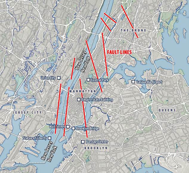
Map via the Daily Mail (2018) who point out that a 7.0 magnitude quake could bring down 6,000 older buildings.