From Artemis:
An early 2019 hurricane season forecast from suggests this year could see a little less Atlantic tropical storm related activity than normal overall, but the recently begun El Niño events strength and persistence is expected to be a major factor here.From the International Research Institute for Climate and Society the plume of model predictions:
NOAA announced the arrival of an El Nino event back in February and as ever it is expected to be a major factor in how many Atlantic tropical storms or hurricanes form during the coming season.
El Nino is expected to be a little on the weak side through spring, hence it is the influence that El Nino could have later in summer that is likely to have the most bearing on hurricane activity in the Atlantic it seems.
Forecasters recently gave a roughly 80% chance that weak El Nino conditions will persist through the Northern Hemisphere spring, with a 60% chance of El Nino conditions persisting into summer, and a 50% chance of El Nino conditions running beyond the summer months.
El Nino’s are often thought to be a driver of less active Atlantic hurricane years and there’s plenty of research to suggest that hurricane numbers and the intensity of tropical storms is perhaps influenced by the occurrence of El Nino conditions and how strong an El Nino is.
But for insurance, reinsurance, ILS and catastrophe bond interests the number of storms is less important than the direction any tropical storms that do form during the season take and their eventual intensity should they interact with land.
Weatherbell Analytics LLC forecaster Joe Bastardi suggests we are in for a hurricane season with below average levels of activity in 2019, in his early season forecast, this includes on an accumulated cyclone energy (ACE) basis, as well as strictly on numbers of storms that form.
Bastardi forecasts between 10 and 15 named tropical storms will form in the Atlantic basis in 2019, with between 4 and 7 becoming hurricanes, and from 0 to 2 attaining major hurricane status....MUCH MORE
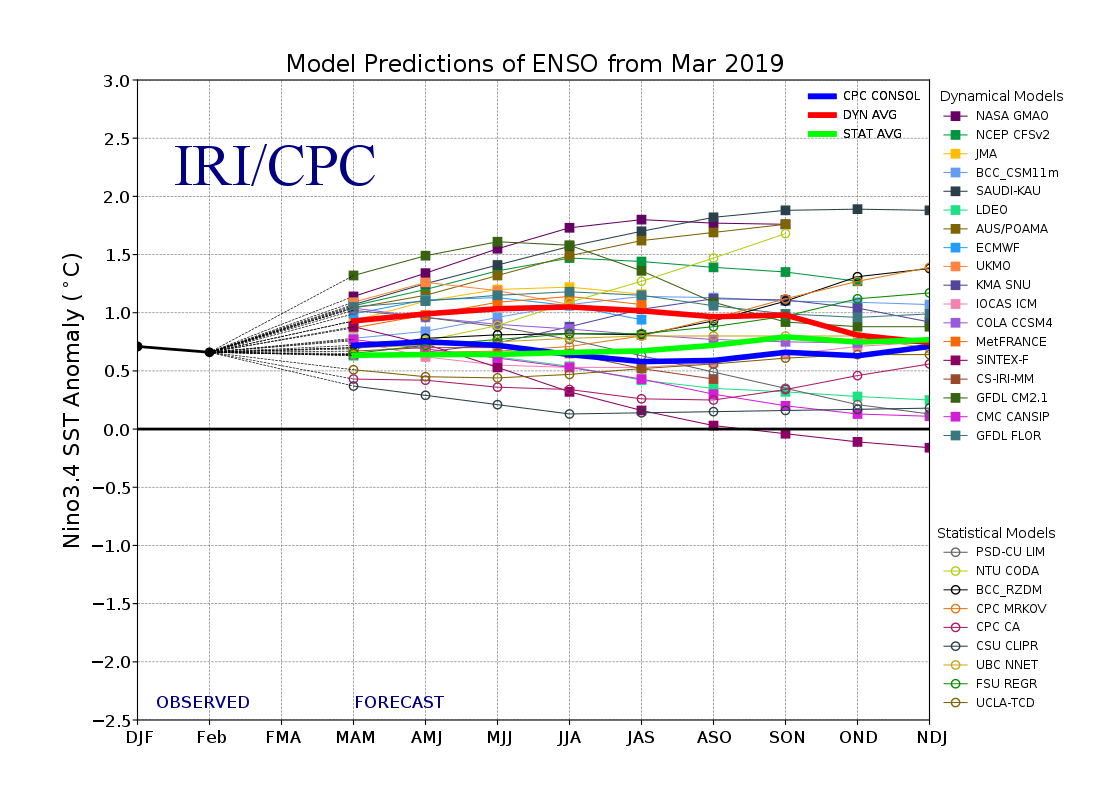
IRI ENSO Forecast
IRI/CPC ENSO Predictions Plume
Published: March 19, 2019
Note on interpreting model forecasts The following graph and table show forecasts made by dynamical and statistical models for SST in the Nino 3.4 region for nine overlapping 3-month periods. Note that the expected skills of the models, based on historical performance, are not equal to one another. The skills also generally decrease as the lead time increases. Thirdly, forecasts made at some times of the year generally have higher skill than forecasts made at other times of the year--namely, they are better when made between June and December than when they are made between February and May. Differences among the forecasts of the models reflect both differences in model design, and actual uncertainty in the forecast of the possible future SST scenario.
And from Australia's Bureau of Meteorology:
El Niño ALERT; likelihood of El Niño in 2019 increases
The El Niño–Southern Oscillation (ENSO) is currently neutral. The Bureau's ENSO Outlook has moved to El Niño ALERT.
This means the chance of El Niño developing in 2019 has increased to approximately 70%, around triple the normal likelihood.
Tropical Pacific sea surface temperatures have touched on El Niño thresholds for the past three weeks, while waters below the surface are also slightly warmer than average. Signs of El Niño in the atmosphere are less clear. While values of the Southern Oscillation Index (SOI) are currently within El Niño bounds, the index is likely to weaken in the coming days. Large swings in the SOI are not uncommon during the southern hemisphere monsoon season. Additionally, trade winds have been closer to normal over the past fortnight after a period of weakened trades in the western tropical Pacific.
Most international climate models suggest sea surface temperatures in the central tropical Pacific Ocean are likely to remain at El Niño levels into winter. Sustained warmer than average ocean waters would increase the likelihood of coupling between the atmosphere and ocean, which would typically cause changes in Australian and global weather patterns. However, current outlooks have less skill for the period beyond May, and therefore predictions for the latter months should be viewed with some caution....MUCH MORE