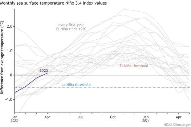
From NOAA's Climate.gov's ENSO blog, May 11:
The tropical Pacific sure knows how to get out of a rut! Just two months after declaring the demise of an almost interminable La Niña, above-average surface temperatures have reclaimed the tropical Pacific, and temperatures in the central-eastern Pacific are expected to continue to rise. Consequently, an El Niño Watch remains in place, with El Niño conditions likely to develop within the next couple of months and then persisting (greater than 90% chance) into the winter.
We care about the potential development of El Niño—the warm phase of ENSO (El Niño/Southern Oscillation, the whole El Niño-La Niña system)—because of the cascade of global impacts that arise from its occurrence, including the expected temperature and precipitation patterns shown here. We’ll revisit many of these impacts in the coming months, but we’ll start by focusing on all the details of these rapidly developing conditions in the tropical Pacific.
On the doorstep
According to ERSSTv5 (our most consistent historical dataset), the April average sea surface temperature in the Niño-3.4 region (our primary monitoring region for ENSO) was 0.1 °C above the long-term (1991–2020) average. This value is up 0.2 °C from March and is the first time the monthly Niño-3.4 temperature was warmer than average since April of 2020.

When we zoom into the weekly time frame, we find that the latest Niño-3.4 measurement from our highest-resolution dataset (OISSTv2.1) was 0.4 °C above the long-term average, even higher than the latest monthly average. This is just a mere 0.1 °C away from the 0.5 °C threshold that is necessary (but not sufficient!) for declaring El Niño conditions. Subsurface ocean temperatures in the tropical Pacific also increased over the past month, providing a source of warmer water that can sustain a developing El Niño. How can La Niña seem like a distant memory so quickly?...
....MUCH MORE
And more next week.